The Branch That Got Away: Hunting Iron Acton's Railway Ghosts on Foot
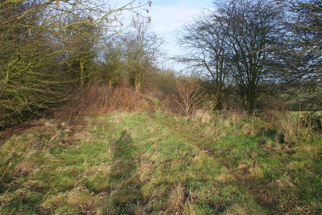
Photo: Kate Jewell, CC BY-SA 2.0, via Wikimedia Commons
Ask most people in Iron Acton what the village is known for and you will get Acton Court, the church, perhaps the allotments. The railway rarely makes the list. Yet for just over seventy years, trains ran through this parish on a branch line from Yate to Thornbury, and the village had a station of its own. The last regular passenger service went in 1944, and the tracks have long gone. What remains is subtler: a road name, a raised hedge bank, a brick abutment, a path that runs straighter than any farm track has a right to. This is a guide to finding those traces without needing an archive pass or a hi-vis jacket.
A Branch Line Built for Quarry Traffic and Market Days
The Yate to Thornbury branch opened in 1872, a modest spur off the main Bristol and Gloucester route. It was never a grand express line. Its job was practical: goods, quarry traffic from around Tytherington, milk, coal, and people going to Yate or Bristol for market, school or work. Iron Acton station sat on the edge of the village, with a single platform, a small goods yard and the sort of waiting room that probably smelled of coal smoke and wet coats. Passenger services were withdrawn in 1944, a wartime economy that never got reversed. Freight lingered on parts of the branch for years afterwards, but the passenger station at Iron Acton became history.
What Survives When the Timetable Goes
Railways are stubborn things. Even when the rails are lifted, the earth remembers. Across the parish you can still spot the railway's fingerprints: embankments that rise a little too neatly above the surrounding fields; hedgerows that run in long, straight lines; bridges and culverts built from blue-black brick; gateposts set at railway angles rather than agricultural ones. Old maps are useful here. The 1880s Ordnance Survey sheets show the branch threading between fields, and comparing them with a modern map is half the fun. You do not need to trespass to see this. Most of the best clues are visible from public footpaths, lanes and roadside verges.
A Short Railway Ramble
This walk is roughly two miles and takes about an hour at a gentle pace. Wear boots in winter, because the path can be muddy, and take an OS Explorer map if you like to know exactly where the parish boundary lies. The route uses public footpaths and lanes; keep dogs under control and close gates.
Start near the village centre, by the church or village hall, and head out along Station Road. The name is the first clue. As the houses thin out, notice how the road curves in a long, easy arc. That is not accidental. Roads that follow old railway alignments often have a smooth, sweeping quality, and this one hints at the branch's route.
Where the road meets the footpath network, follow the signed path along the field edge. Look to your right for a raised bank running parallel with the hedge. That is likely the old embankment, or at least its ghost. In places it has been softened by ploughing and planting, but the line is still there if you squint. A little further on, a brick structure in the hedge line is worth a pause. It may be a small bridge or culvert; either way, the brickwork has the hard, neat look of railway engineering rather than farm repairs.
Continue to the next lane and turn back towards the village on the footpath that loops through the fields. This return leg gives you the best view of the old alignment from the side. In low winter light, the ditch and hedge line can look almost like a cutting. If you have children with you, turn it into a spotting game: who can find the straightest hedge, the oldest brick, the most railway-looking gatepost? The prize can be a hot chocolate at home.
Reading the Landscape Without an Anorak
You do not need to be a railway enthusiast to enjoy this. The trick is to look for repetition and geometry. Railways avoid sharp bends, so their remnants tend to be long and straight. They need drainage, so you often find ditches alongside. They need boundaries, so hedges may be older and more uniform than a field boundary. And they leave behind names. Station Road is the obvious one, but also look for Station Cottages, Old Station Yard or a house that seems to face the wrong way.
If You Want to Dig Deeper
The local history section of the library in Yate, the South Gloucestershire archives and old Ordnance Survey maps are all good starting points. The Thornbury and District Museum may have photographs of the branch in its heyday. And the best source of all is often a neighbour who remembers walking the trackbed as a child. Ask politely, and you may get a story that no map can give you.
The Point of Looking
The lost station is not a theme park. There is no ticket office, no platform sign, no steam train. That is exactly why it is worth finding. It is a reminder that the village was never a frozen picture postcard; it was a working place with goods yards and timetables and people catching the train to Yate. Following the old line is a way of reading that history in the landscape, one hedge bank at a time. And it makes a very good excuse for a Sunday walk.